|
|
|
 |
|
|
|
|
|
|
|
|
|
|
|
|
|
|
|
|
|
|
|
|
|
|
"RIFUGIO MENAGGIO" |
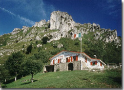 |
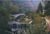
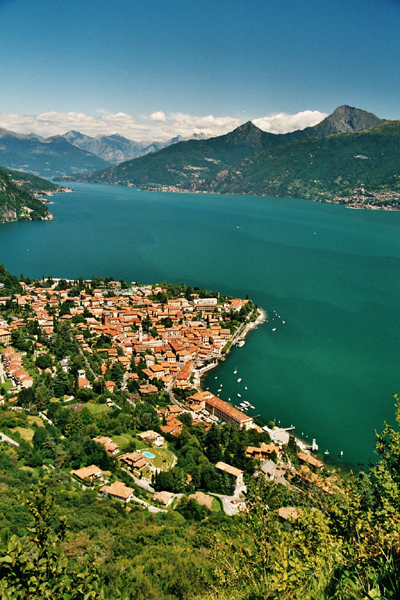
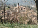
Rifugio Menaggio(1400 m) is situated on the southern slope of Monte Grona (1736 m) and from it one can enjoy a spectacular view of Lake Como and the surrounding mountains.From the rifugio you can extend your hike to Monte Grona 1736 m and to Monte Bregagno 2107 m. The rifugio provides refreshments and lodging and is open on Saturdays Sun- and Holidays.
During the summer daily. |
|
Route from the bus stop at Breglia (749 m) cross the road and ascend the small road leading up to �Monti di Breglia� (sign indicating �Rifugio Menaggio�). At the second bend, just beyond a fountain, you find the first shortcut to the right (sign Monti di Breglia / Rifugio Menaggio). The steep trail ends up on the road again, which you cross to pick up the next shortcut. After 20 m, you turn right following the sign for Rifugio Menaggio. The steep trail leads on to the road once more, which you follow for about 300m. Then you find the next shortcut to the left which leads across a field. Cross the road another time and follow the trail through the woods which leads on to the road at Monti di Breglia (1.000 m) After another 100 m you reach a picnic area with fountain and beautiful view (you deserve a rest). Here you leave the road and follow the trail over some rocks up to the left (sign). Once on this trail you continue to follow the signs. You reach a open space used as parking area which you cross and then pick up the trail to the left. At the junction where you find the metal trail sign we recommend the �sentiero alto� to the right because of the better view. (after heavy snow fall we recommend sentiero basso to the left) It leads among birch trees and broom up to the junction for S.Amate and Monte Bregagno. At this junction you keep to the left. The now even trail leads along the slope and you soon reach the rifugio. Ten minutes from the rifugio there is a viewpoint called �Pizza Coppa� from where you have a view not only of Lake Como but of the whole Menaggio valley with Lake Piano and Lake Lugano. Ten minutes from the rifugio there is a viewpoint called "Pizza Coppa" from where you have a view not only of Lake Como but of the whole Menaggio valley with Lake Piano and Lake Lugano. From the rifugio you can take various hikes on the Prealps; it is also the starting point of the "Alta Via del Lario" - a 3 day hike for experienced hikers. |
|
"MONTE GRONA 1736 m " |
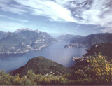 |
From the top of Monte Grona (1736 m) one can admire one of the best views of the Prealps; apart from the three lakes (Como, Lugano and Piano) you can also see the close by peaks of Monte Bregagno, Legnone, Pizzo di Gino, Grigne and if the day is clear enough, many peaks of the Alps from Monviso to Bernina. Here 3 different ways to get to the top of the Grona from Rifugio Menaggio: |
||
|
LA VIA NORMALE - time: 1.15 hrs.; ascent: 336 m the beginning of this trail (the easiest) is behind the rifugio. It leads up to the �Forcoletta� and from there to the left a steep rocky trail leads to the top. LA VIA DIRETTISSIMA - Time: 1 hr; ascent: 336m; the beginning of this trail is behind the rifugio. The steep trail winds up the south face of the mountain. During the winter this trail, as it is exposed to the south, remains snow covered less time compared to the Via Normale on the north side of the mountain. - VIA FERRATA - only for Alpinists with adequate equipment, time: 3 hrs. In order to reach the beginning of the Via Ferrata you follow part of the Via Panoramica. |
|
"S. AMATE AND MONTE BREGAGNO" |
 |
Amazing walk from Rifugio Menaggio to the little chapel
Sant'Amate (1623 m) over the mountain - ridge with a marvelous view of lake Como to south side and a view of the alpine pastures and
Val Sanagra on the north side. |
|
Route In order to reach Rifugio Menaggio see the route description. Pick up the steep trail behind the Rifugio with the indication Forcoletta/Grona Via Normale. At the bifurcation Forcoletta - Grona /S. Amate keep to the left and follow the indication for Forcoletta. Once at the �Forcoletta�, right on the mountain - ridge, you go right (to the left it goes up to the top of the Grona (1736m). Spectacular view on the lake as well as on the woods and pastures of the Val Sanagra. You follow the grassy ridge to the little chapel of S.Amate. If you wish from S.Amate you can follow the ridge to the top of Monte Bregagno (2.107 m - 1.30 hrs.). Back at S.Amate you follow the sign for Breglia. The first part of the trail goes down steeply but then it goes even along the grassy slope of the mountain to a little saddle. Then follows another steep part leading down to the trail (sentiero alto) you followed up to the rifugio; here you turn left to go back to Breglia. |
|
"SASS CORBEE IN VAL SENAGRA" |
 |
This walk follows one the many itineraries leading through the Park Val Sanagra. It will show you various features of the Val Sanagra: the wonderful natural setting, the many traces of traditional activities (mills, lime-pits, the furnace) and the rural settlement of Madri. |
|
Route: From Piazza Garibaldi you pick up Via Calvi. At the end of it you cross the main road and you turn into Via Caronti, along the left side of the Parish church St.Stefano. At the end of the street turn right and after 30 m turn left into Via Castellino da Castello. This street leads to the upper part of the town where once the castle stood. It was destroyed in 1523 by the Signore delle Leghe Grigie . Above the ruins of the ancient castle you find the church S.Carlo (1614) The street then leads down to a road (Via N.Sauro) which you follow to the right. Pick up the path way on the right side of Hotel Loveno in order to cut off a bend. Back on the road follow it (to the left) another 30 m and at the next bend, pick up the street to the left (sign Pianure). You are now in the hamlet Loveno with its splendid villas. To begin with, on the left at the beginning of the street, there is Villa Bel Faggio and after 200 m you pass Villa Garovaglio now owned by the German Federal Republic which hosts the Association �Villa Vigoni Centro Italo � Tedesco� which organizes high level meetings. Villa Mylius Vigoni lies just behind Villa Garovaglio. The park can be visited on reservation onThursday afternoon tel. 0344 361232. Having passed the baroque fa�ade of the church San Lorenzo and the sport centre, you reach �Piamuro�(also called Pianure) a big pasture (40 min. from Menaggio). From Piamuro follow the cart track straight on for about 1 km till you reach the Chapel dell�Artus. The track from here leads down to river. Do not cross the bridge at Mulino Nogara but follow the path on the right side of the river. You pass the ancient brick-furnace �Galli� and then reach �La Chioderia�, once a factory where nails were made, now a trout farm with a typical inn. Pick up the track on the right side of the trout farm. Just past the trout farm you pass the deviation to Barna, reachable in 30 minutes. Continue straight on to �Mulino Carliseppi�(456 m), a mill where not much time ago wheat and corn were ground. Cross the old stone bridge and pick up the path to the right which leads along the bank of the river to Sass Curb�e. Here the passage of the river is obstructed by enormous boulders. Steps hewn in the rock make it possible to climb up the huge monolith and continue your way to an ancient lime-pit (be very careful here to follow the signs). At the ancient lime pit "Fornace della Calce" you will see the deviation for Barna reachable in 30 minutes on route 4a. You continue on route 4 through the woods and after approx. 40 minutes you arrive at the beautiful pasture of Monti di Madri (570 m). From here you turn back the same way you came or back at the lime-pit ,"Fornace della Calce" you can pick up trail 4a which leads through the woods to the hamlet of Barna. You pass the quiet church square with its lovely fountain and then pick up the trail at the other side of town to the right leading back down to Piamuro. |
|
"IL ROGOLONE" |
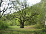 |
An interesting walk, not only because of its natural, but also for its historical aspects. In fact it leads through the historical center of Menaggio, through the village Loveno with its splendid villas, and then into the Val Menaggio. It is an easy walk through the country with lovely views of the Menaggio valley. In the middle of a clearing in the woods stands �Il Rogolone� an enormous oak tree measuring 25 m in height and 8 m in width. |
|
Route: From Piazza Garibaldi you pick up Via Calvi. At the end of it you cross the main road and you turn into Via Caronti, along the left side of the Parish church St.Stefano. At the end of the street turn right and after 30 m turn left into Via Castellino da Castello. This street leads to the upper part of the town where once the castle stood. It was destroyed in 1523 by the Signore delle Leghe Grigie . Above the ruins of the ancient castle you find the church S.Carlo (1614) The street then leads down to a road (Via N.Sauro) which you follow to the right. Pick up the path way on the right side of Hotel Loveno in order to cut off a bend. Back on the road follow it (to the left) another 30 m and at the next bend, pick up the street to the left (sign Pianure). You are now in the hamlet Loveno with its splendid villas. To begin with, on the left at the beginning of the street, there is Villa Bel Faggio and after 200 m you pass Villa Garovaglio now owned by the German Federal Republic which hosts the Association �Villa Vigoni Centro Italo � Tedesco� which organizes high level meetings. Villa Mylius Vigoni lies just behind Villa Garovaglio. The park can be visited on reservation every Thursday afternoon tel. 0344 361232. Having passed the baroque fa�ade of the church San Lorenzo and the sport centre, you reach �Pianure�(also called Piamuro) a big pasture (40 min. from Menaggio). From Piamuro follow the cart track straight on for about 1 km till you reach the Chapel dell�Artus. The track from here leads down to river. Cross the bridge Nogara and follow the mule track as it leads up to Codogna. You reach the road which leads up to Naggio; cross it and pick up the track below the walls on the left side of the 17th century Villa Camozzi (sign Rogolone). It is the seat of the town hall of Grandola and of the Ethnographical and Naturalistic Museum Val Sanagra tel. 0344 32115. From the even track you have a beautiful view of the Val Menaggio with Monte Crocione and Monte Galbiga. The trail then leads into the woods and crosses several streams. At the last stream where there is a rudimental gate, a steep stretch leads uphill to �il Rogolone�. Pick up the trail up on the right side of the clearing (sign Velzo). After a brief stretch uphill, it leads on to another trail which you follow to the right in the direction of Velzo. After having walked for about 30 minutes, the trail becomes a cart track and arrives at the hamlet Velzo. You cross the road (Via delle Alpi) which leads up to Naggio, and you take the track right in front of you which leads to the center of the hamlet. At the house where the street splits, pick up Via Gottro to the right. Keep right and you come to a little piazza with a small chapel where you pick up Via Leopardi on the left. After having passed a washhouse you cross the road and pick up the mule track leading along the side of the beautiful parish church S. Siro. You again reach villa Camozzi (on the opposite side), cross the road near the sport center and pick up via Mulino. You go down to the river following the indications for �agriturismo La Vecchia Chioderia�, where there is a trout farm with typical inn. Cross the bridge and follow the track along the river to the right which again leads to the bridge Nogara. From here you follow the same way as you came, back to Menaggio. |
|
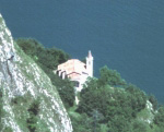
"SAN DOMENICO" |
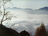 |
The little chapel of S.Domenico (800 m) is situated near Breglia straight over the lake. From it you have a spectacular view of the lake and the surrounding mountains.
From the chapel a path leads through the woods to the Santuario della Madonna di Breglia.
|
|
Route : From the bus stop in Breglia continue straight on to the big parking lot on the right side of the church. A wide mule-track starts off from here to the right, which leads first level and then slightly uphill to the chapel of San Domenico. From the chapel you follow the cart track through the woods, which ends up at a big pasture. You cross the pasture on the track to the left and you find yourself right at the beginning of the steps, which lead up the Santuario. Inside, there is a marble statue of the Virgin Mary which has been venerated for more than two centuries. It was kept in a modest oratory until, in 1777, the present church was built. Along the cobbled steps leading to the sanctuary you find some of the 14 granite stations of �I Misteri del Rosario�. From the Sanctuary you follow the easy lane to the center of Breglia. Near the bus stop you can see a Roman tomb dating back to the VI c. It was custom in the roman age to place tombs along the main roads to keep the memory of the deceased alive. In fact the old roman road, �L�antica Strada Regina�, one of the main connecting roads with the alpine passes, used to pass by Breglia. It lost its importance when the shorter passage over Sasso Rancio, between Menaggio and Acquaseria, was opened. |
|
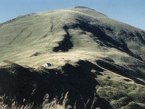
"MONTI DI NAVA" |
 |
This itinerary leads from Croce through the woods up to the pasture fields of Monti di Nava and then descends along a nice track with a marvelous view of the center lake area
and the surrounding mountains to Griante. |
|
Route: From the bus stop at Croce in front of Hotel Adler, continue for about 30 m on the main road. Then cross it and pick up the road in the direction of the golf course. You pass the turn of for the Crocetta and following the signs of path 2 of the "Via dei Monti Lariani", a hiking trail of 125 km connecting the �monti� on the west coast of the lake, you reach the church �La Madonna di Paullo�. The old roman road �L�antica Strada Regina�, one of the main connection roads with the alpine passes, used to lead over Bocchetta di Nava down to Griante. This route was also used by the pilgrims hence the signs of the jubilee. From here the steep cart track leads along the entrance of the Menaggio � Cadenabbia Golf Club and through the area Mi� to the beautiful pastures of �Monti di Nava�at the foot of Monte Crocione. An even track leads to �Bocchetta di Nava� and near the last building (sign Griante) you leave the �Via dei Monti Lariani� (path 2 continues as far as San Fedele d�Intelvi) and you pick up the trail to the left. It leads down in wide bends with a most beautiful view of the peninsula of Lavedo, and the towns of Tremezzo, Mezzegra and Lenno. The trail then turns to the slope above Griante with a splendid view of Sasso San Martina and its little church. You pass the deviation for the cappella degli alpini (reachable in 10 minutes) and shortly after you reach a fork where you keep left. The track ends up on a road that connects Rogaro with Griante; turn left in the direction of Griante. You pass the turn of for the church San Martino that you can reach in 40 min. over an easy track. This road ends up in another road, which you again follow to the left and after 150 m you get to the main road on the lake right in front of the bus stop. (by foot to Menaggio 35 minutes). |
|
"LA CROCETTA" |
 |
La Crocetta (450 m) is a little cross located on top of a hill above Menaggio from where can enjoy
a lovely view of Menaggio and the central lake area.
The walk leads through the woods over an easy mule-track. |
|
Route : From the bus stop continue about 15 m on the main road then cross it and pick up the road in the direction of the golf course (there is a big sign). After about 300 m you turn left into �Via per la Crocetta� also called �Via Pigato�. After some bends the road ends and you continue on a wide track. Before arriving at the Crocetta you encounter some trenches. In fact they are part of the great defense line called �Linea Cadorna�, built in 1915 along the Swiss-Italian border, fearing a possible German offence. In the province of Como it extended from Monte Bisbino near Como to Sasso Cordona, Monte Galbiga and Monte Crocione and from there down to the Crocetta . Close by stands the little chapel dedicated to the �arm of the Alpini�� near the view point of the Crocetta. |
|
"IL LAGO DI PIANO" |
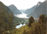 |
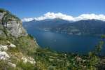
The small Lake Piano, situated in the Val Menaggio between Lake Como and Lake Lugano,
is a protected natural oasis and is a breeding place for many types of water birds.
The easy trail leads along the foot of Monte Galbiga through woods and fields.
Very interesting is the Castel San Pietro, a medieval fortified rural group of houses on the penisola "Brioni". You will also follow part of the ex trainline Porlezza - Menaggio
supressed in 1935 and now converted into a cycle and foot path. |
|
Route: From the bus stop �La Santa�, cross the main road and pass the little church �La Santa� on the left side. Take the path / stairway to the left which leads down to a crossroad. Follow the sign for Bene Lario. Ignore the cart track �Portaiola antichi Mulini� and pick up the road leading uphill to Piazza Comunale. Then follow Via Cavour which leads to Piazza Garibaldi. Here you pick up Via del Torchio on the right, which soon becomes a cart track. It leads to the old wash house �Lavatoio del Lembra� and from there to �Antichi Mulini� (sign) (old mills). Here begins the protected oasis of Lago di Piano (sign and map). Continue to the left. The cart track becomes a path with view of a large reedy area. You soon reach the southern shore of the lake, which you follow for about 500 m. You then reach a private property with a not very evident fencing and here you pick up the trail going uphill to the left, which after ca. 30 m ends, on a large cart-track; turn right. You soon arrive at ex camp site �ok la rivetta� where we recommend a stop on the little public beach. Continue ca. 200 m on a tarred road and then turn right. After ca. 300 m you see �Castel San Pietro� up on the right. Follow the alley leading up to the old settlement with its houses clustered close to each other and with only one entrance closed by a gate. The stone wall, the small arched windows, the narrow passages give the idea of a fort and how it used be in the Middle Ages. Turn back to the beginning of the alley and take to the right. You soon reach a cycle / footpath which you follow to the right. This path follows the itineray of the ex trainline Porlezza - Menaggio supressed in 1935 and now converted into a cycle and foot path. The continuation as far as Menaggio is foreseen within 1010. Soon you reach the �casa della riserva� with picnic tables, an information office, a small ecomuseum and the possibility of hiring rowing boats and mountainbikes tel. 0344 74961. From here follow the lake and just past the entrance of camp-site Ranocchio, turn right in order to continue on the cycle- / footpath which leads back to BENE LARIO. When you reach the tarred road turn left to reach again the bus stop at "La Santa". |
|
"L�ANTICA STRADA REGINA" |
 |
The Antica Strada Regina, which leads along the west coast
of Lake Como at an average height of 300 m is of very old origins.
It follows some stretches of today's main road but runs mostly parallel to it.
It was in use till the end of the 18th century when today's road on the lake (also called Regina)
was built. This stretch starts at Nobiallo and leads along the slopes of "Sasso Rancio"
to Rezzonico with splendid views of the lake. |
|
Route: From Piazza Garibaldi follow the lake promenade "Lungo Lago Castelli" and pass by the Lido Giardino. Once you meet the main road follow it in the direction of Colico (north). Just before the entrance of the tunnel you pick up the road on the right side of it which is only for pedestrians. It passes the rock-climbing gym and at then leads on to the main road again which you follow for about 150 m, paying attention to the traffic. You are now at the village Nobiallo. At the point where you find the indication for "carabinieri" on the left, you leave the main road and pick up the street leading to the carabinieri station and the church of S.Bartolomeo and Nicolao with its leaning bell-tower of the 13th century. Having left the village of Nobiallo behind, you arrive at the"Santuario della Madonna della Pace". From here the "Vecchia Strada Regina" starts to climb up the slopes of "Sasso Rancio". You see the "Villa La Gaeta" built in the twenties and you pass a new residence where you cross a private road and continue straight on. The track eventually leads down to a road, which you follow left. You then reach the main road in between two tunnels. Paying attention to the traffic, follow it to the entrance of the next tunnel where you pick up the road on the right of the entrance. After 30 m there is a track on the left which leads to Acquaseria. In the village Molvedo the old road is interrupted by the park of a villa. You again follow the main road for about 50 m and then take the stairs at the end of the villas fencing. Continuing on the "Antica Strada" you arrive at Rezzonico and go down to its beautiful picturesque harbor. Having passed under the portico the alley leads up to the castle of Rezzonico with a tower from the 14 century. From here you go to the main road where you find the bus stop. |
|
"SAN MARTINO" |
 |
San Martino is a small church located on the slopes of Sasso di S.Martino above Griante
at a height of 475 m. An easy mule-track leads to the church
from where you have a lovely view of the central lake area. |
|
Route : You get off the bus at the intersection for Griante (bus stop bivio per Griante) on the main road Menaggio � Como and turn right and follow the road in the direction of Griante. After about 100 m. you turn right and follow another road leading steeply uphill. After about 300 m you leave it and you follow the sign for San Martino to the right. An easy mule track leads up in wide bends to the little church Along your way you will pass a series of little chapels decorated with mosaics representing various stages of Christ�s life. About half way you encounter the chapel Cappella degli Alpini, dedicated to S. Carlo. The S. Martino church was built in the XVI century to house the wooden statue of the 14th century representing the Madonna with Child. The legend tells that the statue was found in the 16th century by a shepherd girl in a cave in the mountains where it was put a century before by an inhabitant of Menaggio when the town was destroyed by the Grigioni. The statue was brought down to the parish church where it miraculously disappeared and was found again on the Sasso di S. Martino. This was interpreted as the desire of Maria to be venerated on the mountain. First a small shrine was built and then the church. |
|
"From Breglia to Menaggio" |
 |
This walk follows a brief stretch of the "Via dei Monti Lariani" - a marvelous hiking trail of 125 km.
It leads almost completely downhill through the woods, through the picturesque village of Barna
with its lovely church square and through the Parco Val Sanagra. |
|
Route: From the bus stop at Breglia turn left and pass in front of the hotel Albergo Breglia. During the first part of this walk you will follow the signs of two different trekking routes: the Via dei Monti Lariani, (red, white, red 3), a marvellous hiking trail of 125 km, and the Sentiero delle 4 Valli, another beautiful hiking trail of 50 km (the 3 crossed with a stripe) as these two hiking routes, for a brief stretch, follow the same itinerary. You leave the hamlet Breglia behind you and cross a small wooden bridge near the spring of Troi. From here it goes uphill through the woods to the area called Ponte, where there are many summer houses and a holiday camp. You reach a small road and follow it downhill to the pastures of La Piazza. At the intersection, where there is a little chapel called "del Bergum�, turn right. Pay attention, the two hiking trails split here. The 4 Valley Trail leads immediately again to the right, the Via dei Monti Lariani continues straight on, so go straight on. You pass an area with barbecue and pic-nic tables used in the summer for some of the local village feasts and at the end of La Piazza go left. Near an isolated house you leave the cart track and pick up the trail down along the fencing of the house through the woods. The not very clear path leads to a fountain with 3 arcades. From here an old mule track leads down to the hamlet Barna with its lovely church square. Pay attention to the signs on the houses and follow the mule track called "La Pendola", because of enormous boulder blocked in the gorge, down into to the valley of the river Sanagra. The mule-track ends up in a cart track which you follow left to Mulino Chioderia where there is a typical inn with trout farm. At this point you leave the Via dei Monti Lariani that continues across the bridge in front of the inn called La Vecchia Chioderia; you now follow the trail signs in the direction of Mulino della Valle and Piamuro along the bank of the river Sanagra. At Mulino della Valle you leave the river and follow the cart track that ascends to the left to the chapel dell'Artus. From here you continue straight on to Piamuro, a big pasture. You now follow the small paved road that leads down to the hamlet Loveno passing by the sport center and the church San Lorenzo. The hamlet Loveno is known for its splendid villas like Villa Garovaglio now owned by the German Federal Republic which hosts the Association �Villa Vigoni Centro Italo � Tedesco� and organizes high level meetings. Villa Mylius Vigoni lies just behind Villa Garovaglio. The park can be visited on reservation every Thursday afternoon tel. 0344 361232. Then further down in Via N. Sauro you pass Villa Bel Faggio just before reaching the road that connects Menaggio with Breglia. Follow it to the right using the side walk. About 100 m past the Hotel Loveno pick up Via per Loveno to the left which leads down to the centre of Menaggio. |
|
tel. +39 338 6085190 |
e-mail info@milohouse.it |