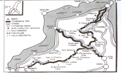
"LA DORSALE DEL TRIANGOLO LARIANO"
Itinerary :
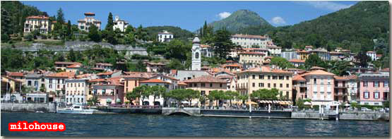
Como � Brunate - Colma del Piano � Bellagio
Length: 30 km
Ascent: 1.160 m
Maximum height: 1.536 m (Terra Biotta)
Route: 90% on tracks
Difficulty: medium
Physical effort: strenuous
|
"LA DORSALE DEL TRIANGOLO LARIANO"
Route:
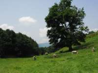
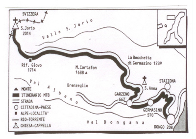
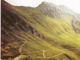
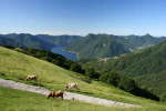
BRUNATE (715 m) From Como you take the funicular up to Brunate (spectacular view of the lake, the town Como, and the alps). From the funicular station follow the road to SAN MAURIZIO (906 m) and at the square you pick up the road �Via alle Colme�. After a tiring ascent you reach Piazzale C.A.O., which you cross in order to pick up the road to the left which leads past Rifugio C.A.O . (980 m). The trail continues through the woods and soon reaches BAITA CARLA (997 m). A cart-track leads along the slopes of Pizzo 3 Termini, to BAITA BONDELLA (1.075 m) from where you have a most beautiful view of the Alps, the Alpi Marittime, and the small lake of Montorfano. The trail continues to RISTORO DEL BOLETTO FABRIZIO (1.100 m -) Just past this inn, after a brief ascent, the Dorsale, leads along the north side of the mountain ridge with a beautiful view of Lake Como and the surrounding mountains. After a level stretch the path leads down to the BOCCHETTA DI MOLINA (1.116 m)close to the ex Capanna San Pietro You ignore the deviation to the right. From Bocchetta di Lemna the trail heads northwards with a beautiful view of the valley of Caslino d'Erba, the tops of the Resegone and Monte Pallanzone. A steep trail runs along the woody east slope of Pizzo dell'Asino. After you have passed two streams (note the formation of the sedimentary layers) you reach BOCCHETTA DI PALANZO (1.210 m) situated between the Val di Cairo to the west and Val Piot to the east, a real crossroad of trails. The trail leads you along the west slope of Monte Palanzone to RIFUGIO RIELLA also called Rifugio Palanzone (1.275 m )From here you have a beautiful view of Lake Como, Faggeto Lario and the surrounding mountains. You soon arrive at CIPPO MARELLI (1.293 m.) and at BOCHETTA DI NESSO. You pass the extended fields of Preaola on a level track which leads around Monte Palanzone with a nice view down on Pian di Nesso and Monte San Primo. You then arrive at BOCCHETTA DI CAGLIO (1.297 m. - time 0.20; 4.30 hrs.). You ignore the trail to the right leading down to Caglio. and continue uphill along the slope of Monte Croce (1.351 m). The large track leads to the beginning of Braga di Cavallo (1.350 m), where you notice a group of isolated beech trees. Here to the right, the steep descent starts to Pianchetta (1.243 m). After a brief stretch uphill, the steep descent continues over the ridge to COLMA DI CAGLIO (1.129 m ) At the fork in front of Monte Fal� (1.182 m), you pick up the large cart-track to the left which leads down to COLMA DEL PIANO also called Colma di Sormano (1.124 m - time 0.20; 5.20 hrs) where there is an inn. N.B. At this point you can choose to interrupt and cycle down to Pian del Tivano from where you can descend to Nesso and from there either back to Como or Bellagio. For the ones proceeding pick up the large cart trek just past the restaurant Baita Colma. The track leads up to Colma dei Cippiei 1.185 m, and past the Colma del Bosco in order to arrive at ALPE SPESSOLA (1.237 m) From here you continue on the track as it winds rather steeply uphill with splendid views of the Val di Torno, the tops of the Grigne and "i Corni di Canzo" to ALPE DI TERRA BIOTTA (1.536 m) Just past the farmhouse, you reach the highest point of this route where you enjoy the view of the promontory of Bellagio and the surrounding mountains. Cross the field to the right and near the small "polla�, a beverage place for cattle, pick up the trail to the right which descends to ALPE DEL BORGO (1.180 m..). During the summer months excellent cheese is produced here. From this point you follow the rural road down to the settlement BORGO SAN PRIMO (1.107 m) inn - bus stop (bus service only during the summer months) At the restaurant "La Baita" you get to a road which you follow to the left. You pass the ex holiday-camp Bonomelli on your way to Alpe delle Ville. Just out of the pine wood (slightly before the deviation for Rifugio Martina, you leave the track and turn right and pass in front of a small house. The path leads for rather a long stretch through a wood (pay attention to the signs) and finally arrives at the pastures of PAUM (957 m - time 0.45; 3.15 hrs.) From here a rural road leads downhill with a nice view of "Pra Filippo" and the village "Cernobbio", situated on the other side of the Val del Perlo. To the villane ROVENZA (724 m -) Here you leave the Dorsale and at the fountain you turn lungo il lago fino Como.to right, and follow the road to Bellagio.
|