|
"Via dei monti Lariani - path 1"
PATH 1
CERNOBBIO - SAN FEDELE D'INTELVI
Time: 9.30 HOURS
Distance : 28 KM
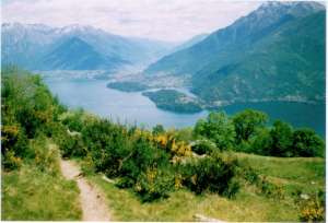
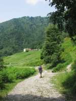
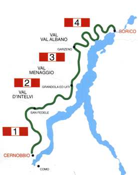
CERNOBBIO (200 m.) The 'VIA DEI MONTI LARIANI' starts at Cernobbio in Piazza Mazzini where the main bus stop is. Cross the main road, pick up Via A. Volta and when you get to a circus continue straight on in the direction of Rovenna and Monte Bisbino. At the end of the road, just past the bend, after 20 m, pick up Via G. Parini on the left. Once on the road again, follow it as far as Casnedo and at the church turn right. Cross a bridge and take left and pass through the village Stomaino. A shortcut leads to ROVENNA (450 m. 0.45 hours) – which can also be reached by bus (line C28) from Cernobbio. You pass the church square (where also the bus stop is). At the bend turn left following the indications for Scarone and Madrona. After a brief stretch you reach the beginning of the mule track that leads up in large bends to MONTE SCARONE and from there to MADRONA (850 m. 1.00 ; 1.45 hours). Follow the road up to the second curve, where you pick up the mule-track to Monte Bisbino which passes by the chapel of S. Carlo. At the end of the mule-track, before reaching the road leading to the top of Monte Bisbino turn right in order to reach CA' BOSSI (1188 n. 1.00 ; 2.45 hours). From here a wide track goes slightly downhill to COLMA DAL BUGONE (1200 m. 0.40 , 3.25 hours).– Rifugio Bugone - This is where two paths coming up from Moltrasio meet. You pass ancient beech-woods and get beautiful views of the lake, the Western Alps, Monte Generoso and Sasso Gordona. Past COLMA DEL CRINCO the 'VIA' leads on to the COLMA DEI MURELLI (1200 m 0.45 ; 4.05 hours).– Rifugio Murelli From this point you can make a detour of about half an hour to Monte Colmegnone (1383 m.), which has a magnificent view, or Monte San Bernardo (1348 m.) with its characteristic little church. From here an easy cart-track leads to ALPE DI CARATE where you pick up the mule-track to RIFUGIO BINATE (1200 m. 0.35 ; 4.40 hours) From here the mule-track becomes a path which runs half way up the mountainside, the Swiss-facing slope, through fields and alpine pastures to COLMA DI SCHIGNANO (also called delle Crocette) (1135 m. 0.20 ; 5.00 hours) from here it’s possible to go down to Schignano (0,45 min) where there is a bus stop or to Argegno (2.00 hrs). At the next intersection at the height of a cross, take right over to the side that faces the Val d' Intelvi and continue on an old military road that leads around Sasso Gordona. Inside this mountain there are tunnels with emplacements. In fact Sasso Gordona was part of the great defence line called Linea Cadorna, built in 1915 along the Swiss-Italian border, to thwart a possible German offence. At the intersection with the indication Alpe Cerano / San Fedele turn right. (The ones who have booked an overnight stay at Rifugio Prabello go straight on and will reach the “rifugio” in about 15 min.) An easy track leads down to ALPE DI CERANO (960 m 0.50 ; 5.50 hrs) (also called Pian delle Alpi) - road connection with Casasco 40 min. where there is a bus stop (line C21). Follow the road Casasco to Erbonne to the right, and just past the pic-nic area leave the road and pick up the mule-track to the left in the direction of Erbonne (sign). At the intersection with some trail signs on a tree, turn right and follow the track that leads up the farm house of ERMOGNA. Before reaching the farm house you pass a “bolla” a natural depression in the terrain adapted by man to conserve rainwater and create a beverage place for the cattle. Near the farmstead you notice a cylindrical formed construction called “nevera”. These constructions out of stone, which lead deep into the ground, were filled with snow (neve) and used in the summer to conserve food. The easy track leads to MONTE di CAROLZA (1100 m.). and from there after a stretch through the woods you reach some recently built houses above the town Casasco. Take left and follow the sign for Capanna Bruno / San Fedele. Then you reach the road coming up from Casasco, follow it to the left and just past to the bend with three crosses, leave the road and take the trail on the left as it leads up to the restaurant CAPANNA GIUSEPPE AND BRUNO (1180 m. 1.30 ; 7.20 hours). Just past the restaurant on the right you find the trail signs for Alpe Orimento / San Fedele. An almost flat trail leads over the steep fields of Mt. Crocione, and crosses under a ski lift. The trail leads on to a track and after a stretch downhill at the intersection, take the trail left leading uphill. At the next intersection keep left again in order to reach BOCCA DI ORIMENTO (1275 m. 0.45 ; 8.05 hours) restaurant, starting point of the excursion to Monte Generoso (1701 m.) Follow the road leading down to Casasco to the right and after approx. 2 km you reach RIFUGIO CRISTE' (1250 m.) You remain on the road (there are some shortcuts in order to cut some bends) which leads around two “bolle” and arrives at an intersection. You leave the road leading to the right to Casasco but follow the road left in the direction of San Fedele. After 300 m you leave it and pick up a large cart track on the left leading to some houses. The cart track becomes a comfortable grassy trail, that leads through a pinewood and then down through meadowland in the direction of SAN FEDELE, with splendid views of the VAL D'INTELVI and the mountains of the Canton Ticino. The trail leads on to the road leading down to the town SAN FEDELE D'INTELVI (750 m. 1.25 ; 9.30 hours)- hotels - restaurants – bus stop (line C20/21/22). where this section ends near the bus depot.
|
